Visit! You will not be sorry!
Wednesday, May 8, 2013
The Pacific Northwest
Because this chapter does not bring up any new topics that the previous chapters have not already discussed, I decided to use this section to talk about Northern Lights, the reason Alaska is so intriguing to me. As hard as it is to believe, the images below are real and quite possibly one of the most beautiful things a person can be lucky enough to experience on earth.


An aurora (plural: aurorae or auroras; from the Latin word aurora, "sunrise") is a natural light display in the sky particularly in the high latitude (Arctic and Antarctic) regions, caused by the collision of energetic charged particles with atoms in the high altitude atmosphere (thermosphere). The charged particles originate in the magnetosphere and solar wind and, on Earth, are directed by the Earth's magnetic field into the atmosphere. Most aurorae occur in a band known as the auroral zone,[1][2] which is typically 3° to 6° in latitudinal extent and at all local times or longitudes. The auroral zone is typically 10° to 20° from the magnetic pole defined by the axis of the Earth's magnetic dipole. During a geomagnetic storm, the auroral zone expands to lower latitudes.
Aurorae are classified as diffuse or discrete. The diffuse aurora is a featureless glow in the sky that may not be visible to the naked eye, even on a dark night. It defines the extent of the auroral zone. The discrete aurorae are sharply defined features within the diffuse aurora that vary in brightness from just barely visible to the naked eye, to bright enough to read a newspaper by at night. Discrete aurorae are usually seen only in the night sky, because they are not as bright as the sunlit sky. Aurorae occasionally occur poleward of the auroral zone as diffuse patches[3] or arcs (polar cap arcs[4]), which are generally invisible to the naked eye. (wikipedia)


When to Go
Since you can only see them at night, you want to come when there is the most darkness—from September until about April 20; that’s when there are: 1) frequent displays, 2) clear skies, and 3) generally mild weather.
Where to Go
While you can potentially see them all over the state, the most reliable spot is Fairbanks. Up and inland, Fairbanks is geographically under the "aurora oval," where auroras are seen most frequently. You can even take excursions several hours north from there, offered by operators such as Northern Alaska Tour Company.
How-To Tips
The aurora is unpredictable, and no one's entirely sure when—or where—it's going to appear. But here are some tips to give you the best odds of seeing the aurora in Alaska.
Look at the Right Time of Day
Start looking about an hour and a half after sunset, but peak auroral activity is between 10 p.m. and 2 a.m. solar time. (Solar time is 2.5 hours after clock time during daylight saving time (and 1.5 hours after during standard daylight time. That means the best time for seeing the aurora during Alaska's winter is 11:30 p.m.–3:30 a.m. with the peak at 1:30 a.m. During Alaska's spring and fall (September and March), the best time to view the aurora is 12:30 a.m.– 4:30 a.m.
Look for the Right Weather Conditions
If it's clear and dark enough to see stars, there's a chance you'll be able to see the aurora. If there's even partly cloudy skies? You have a chance, but it needs to be a strong aurora for you to see it. Check out these two prediction tools:
- Look at the weather forecast for the town you're in.
- Get the aurora forecast from the UAF Geophysical Institute. (http://www.alaska.org/things-to-do/northern-lights-viewing)

The northern lights are just about the only thing that could get Alaskans to stand outside without a coat in January.
But there the lights are, flipping and waving through the sky in shades of green, purple and red. And there are Alaskans, calling neighbors outside for a look and putting cameras on tripods in the middle of the night.
Usually the aurora borealis appears to the north of the viewer, but occasionally it seems to be directly overhead even as far south as Anchorage, which sits just north of 61 degrees north latitude.
Many Anchorage aurora fans drive north during the winter in search of brighter and more colorful lights, sometimes ending up in Talkeetna at the foothills of the Alaska Range. (Leon Unruh)

California
As chapter 15 spent time discussing the Earthquakes and fault lines in California, this blog entry will be about Earthquakes and natural disasters in Alaska.


.jpg)


The 1964 Alaskan earthquake, also known as the Great Alaskan Earthquake, the Portage Earthquake and the Good Friday Earthquake, was a megathrust earthquake that began at 5:36 P.M. AST on Good Friday, March 27, 1964.[2] Across south-central Alaska, ground fissures, collapsing structures, and tsunamis resulting from the earthquake caused about 143 deaths.
Lasting nearly three minutes, it was the most powerful recorded earthquake in U.S. and North American history, and thesecond most powerful ever measured by seismograph.[3] It had a magnitude of 9.2, making it the second largest earthquake in recorded history[2][4]—the largest being the 1960 Valdivia earthquake in Chile. [3]
The powerful earthquake produced earthquake liquefaction in the region. Ground fissures and failures caused major structural damage in several communities, much damage to property and several landslides. Anchorage sustained great destruction or damage to many inadequately engineered houses, buildings, and infrastructure (paved streets, sidewalks, water and sewer mains, electrical systems, and other man-made equipment), particularly in the several landslide zones along Knik Arm. Two hundred miles southwest, some areas near Kodiak were permanently raised by 30 feet (9.1 m). Southeast of Anchorage, areas around the head of Turnagain Arm near Girdwood and Portage dropped as much as 8 feet (2.4 m), requiring reconstruction and fill to raise the Seward Highway above the new high tide mark.
In Prince William Sound, Port Valdez suffered a massive underwater landslide, resulting in the deaths of 30 people between the collapse of the Valdez city harbor and docks, and inside the ship that was docked there at the time. Nearby, a 27-foot (8.2 m) tsunami destroyed the village of Chenega, killing 23 of the 68 people who lived there; survivors out-ran the wave, climbing to high ground. Post-quake tsunamis severely affected Whittier, Seward, Kodiak, and other Alaskan communities, as well as people and property in British Columbia, Oregon, and California. Tsunamis also caused damage in Hawaii and Japan. Evidence of motion directly related to the earthquake was reported from all over the earth.(wikipedia)

Anchorage area
Most damage occurred in Anchorage, 75 mi (120 km) northwest of the epicenter. Anchorage was not hit by tsunamis, butdowntown Anchorage was heavily damaged, and parts of the city built on sandy bluffs overlying "Bootlegger Cove clay" near Cook Inlet, most notably the Turnagain neighborhood, suffered landslide damage. The neighborhood lost 75 houses in the landslide, and the destroyed area has since been turned into Earthquake Park. The Government Hill school suffered from the Government Hill landslide leaving it in two jagged, broken pieces. Land overlooking the Ship Creek valley near the Alaska Railroad yards also slid, destroying many acres of buildings and city blocks in downtown Anchorage. Most other areas of the city were only moderately damaged. The 60-foot concrete control tower at Anchorage International Airport was not engineered to withstand earthquake activity and collapsed, killing one employee.[7]
The house at 918 W. 10th Avenue suffered damage peripherally, but one block away the recently completed and still unoccupied Four Seasons Building on Ninth Avenue collapsed completely with one whole wing sticking up out of the rubble like a seesaw.
Elsewhere in Alaska
The hamlets of Girdwood and Portage, located 30 and 40 mi (60 km) southeast of central Anchorage on the Turnagain Arm, were destroyed by subsidence and subsequent tidal action. Girdwood was relocated inland and Portage was abandoned. About 20 miles (32 km) of the Seward Highway sank below the high-water mark of Turnagain Arm; the highway and its bridges were raised and rebuilt in 1964-66.
Most coastal towns in the Prince William Sound, Kenai Peninsula, and Kodiak Island areas, especially the major ports ofSeward, Whittier and Kodiak were heavily damaged by a combination of seismic activity, subsidence, post-quake tsunamis and/or earthquake-caused fires. Valdez was not totally destroyed, but after three years, the town relocated to higher ground 7 km (4 mi) west of its original site. Some Alaska Native villages, including Chenega and Afognak, were destroyed or damaged. The earthquake caused the Cold-War era ballistic missile detection radar of Clear Air Force Station to go offline for six minutes, the only unscheduled interruption in its operational history. Near Cordova, the Million Dollar Bridge crossing the Copper River also collapsed. The community of Girdwood was also confined to the southern side of the Seward Highway when water rushed into Turnagain Arm arm and flooded or destroyed any buildings left standing to the north of the highway. Interestingly, only the ground immediately along the highway and that on the north side of the road dropped, prompting geologists to speculate that Girdwood may rest upon an ancient cliff face, now covered by countless thousands of years of sediment and glacial deposits.[citation needed]

.jpg)
MexAmerica
Although Alaska is a long way away from the Mexican border, immigrants are attracted to the area for promising job opportunities like fishing. As you can see from the picture below, the Mexican-Born population in Alaska is between 0 and .9%.

"Federal officials said they are unable to estimate the exact number of undocumented immigrants in Alaska, but there are indications the numbers are rising.


"Federal officials said they are unable to estimate the exact number of undocumented immigrants in Alaska, but there are indications the numbers are rising.
Since January 1991, they arrested 462 undocumented immigrants in Alaska, 40 percent with jobs.
The seasonal fishing and fish-processing industry in Alaska in recent years has grown increasingly dependent on foreign labor.
At one Kodiak fish cannery this summer, a reporter found nearly half the 125 workers were Mexican or Salvadoran.
The rest were Filipino, a few whites and one Eskimo.
Getting here is easy. The job seekers board airplanes in Mexico City or Los Angeles and fly into Anchorage International Airport. From there, they take planes to small coastal communities.
With several weeks' work they make up the air fare.
Some of the undocumented migrants are victims of scams, however.
Employment "agencies" run ads in Spanish-language newspapers sold along the Mexico-U.S. border, promising high-paying jobs in Alaska for a fee.
Those who fall for this usually find no jobs, or low-paying positions." written by John Enders

As a result of the increasing number of Mexican immigrants, more and more of their culture can be found in the state of Alaska. For example, restaurants are opening throughout the state with the flare and flavors of Mexico.


Due to the low number of Mexican-Born Alaskans, racism is an undeniable issue in the state. For example, the Republican Rep, Don Young was quoted referring to the Mexican race in derogatory terms.

It is important to be understanding of people different than yourself. Hopefully the increase in immigration will increase the people of Alaska's tolerance for other races.
Rocky Mountain Region & The Intermontane West

Alaska possesses many mountain ranges that make up its beautiful topography. Geologists note that Alaska’ physiographic regions were formed by forces originating deep within the earth. The movement of molten material deep within the earth has caused the shaping of mountains and valleys on the surface. In the process, rigid surface geologic units called “terranes” have moved great distances over time. Geologic units similar to those found in the Wrangell Mountains are also found in Canada and even Idaho to the south. Geologists divide Alaska into four broad terrane units, the North American Stable Platform (which contains some of the oldest rocks in North America),Terranes Originating in North America (approximately the Intermontane physiographic region), Terranes originating in the Arctic Ocean, and Terranes Originating in the Pacific Ocean. (http://www.akhistorycourse.org/articles/article.php?artID=123)

Major Alaskan Mountain Ranges
Alaska Range
The Alaska Range is perhaps the most well-known mountain range in Alaska. It is home to Denali National Park and the giant mountain itself, Denali (you may know it better by its white-man name, Mt. McKinley). This mountain range is one of Alaska's largest, starting at Alaska's eastern border with Canada, arcing across the north of Southcentral Alaska, ending to the west of the Kenai Peninsula.
On November 3, 2002, a massive 7.9 earthquake was caused by a fault running through the Alaska Range. For several weeks afterwards, thousands of aftershocks were recorded. Due to Alaska's sparse population, earthquake damage was only about $20 million.
If you measure from base to peak, you'd find that Denali is much taller than Everest. Denali's base is only about 2,000 feet (610 meters) above sea level, whereas Everest's base is around 14,000 feet (4,267 meters). In fact, Denali is one of the most massive mountains in the world.
Highest Peak: Denali, 20,320 feet (6,194 meters)
Notable Mountains:
- Denali, tallest mountain on North American continent; measured base-to-peak, one of the tallest mountains in the world.
- Spurr, an active volcano west of Anchorage that erupted in 1992 and covered Anchorage with a thin layer of ash.
Aleutian Range
The Aleutian Range begins on the western shores of Cook Inlet, across from the city of Kenai on the Kenai Peninsula. It extends to the southwest along the Alaska Peninsula, eventually entering the Pacific Ocean and forming a chain of islands over a thousand miles long. These islands gradually arc northwards towards Siberia.
Collision between continental plates has created a 1,400 mile (2,253 km) chain of active volcanoes in this mountain range.
Highest Peak: Redoubt, 10,197 feet (3,108 meters)
Notable Mountans:
- Iliamna and Redoubt, two active volcanoes.
- Katmai, a volcano that erupted in 1912, throwing about 33 million tons of rock into the air over two days. Ash and dust was blown as high as 25 miles (40 km) into the air.
Brooks Range
The Brooks Range is Alaska's northernmost mountain range, all of it being located above the arctic circle. This range stretches about 720 miles (1,159 km) from Alaska's eastern border with Canada to the Chukchi Sea off Alaska's west coast. Despite their northerly location and cool temperatures, there are few glaciers in this mountain range; this area is rather arid so not enough snow falls during the winter to create large glaciers. The largest glaciers in the Brooks Range aren't much longer than file miles (eight km).
Highest Peak: Mt. Isto, 9,050 feet (2,758 meters)
Notable Mountans:
- Arrigetch Peaks, considered by many to be the most dramatic peaks of the western Brooks Range, perhaps the most dramatic in all of Alaska.
Chugach Mountains
The Chugach Mountains begin near the Alaskan panhandle and form the coast along much of Southcentral Alaska. These mountains contain the greatest concentration of glacial ice in Alaska. As the warm, moist winter air off the ocean meets these mountains and cools, it creates some of the highest snowfall in Alaska. During the winter of 1952-1953, Thompson Pass near Valdez received about 81 feet (25 meters) of snow.
A major fault in Prince William Sound is contributing to the ongoing formation of these mountains. In 1964, this fault slipped, creating the Good Friday Earthquake that severely damaged Anchorage and destroyed several smaller communities including Chenega, Seward, and Valdez.
Highest Peak: Mount Marcus Baker, 13,176 feet (4,016 meters)
Notable Mountains:
- Alyeska, Alaska's most popular ski resort.
- Girls Mountain, site of Worthington Glacier, Alaska's most accessible glacier.
Coast Mountains
This mountain range is appropriately named, most of it lying along the coastal areas of Southeastern Alaska. A line drawn from peak-to-peak of many of these mountains forms the boundary between Alaska and British Columbia.
Flat land is hard to come by in this area. Many communities such as Juneau and Ketchikan are built on the sides of mountains. Other communities like Skagway occupy narrow valley floors. The terrain is so rough and rugged that there are no roads to connect the communities; all travel is by air or boat.
As the Coast Mountains enter the ocean they create the Alexander Archipelago as well as the other thousand or so islands that make up Southeast Alaska. These islands protect the coastal parts of the mainland from the rough waters of the Gulf of Alaska.
Highest Peak: Kate's Needle, 10,023 feet (3,055 meters)
Kenai Mountains
The Kenai Mountains cover all but the northern and western portions of the Kenai Peninsula. Many glacier-carved lakes dot the Kenai Peninsula, including Kenai Lake, Upper Russian Lake, and Trail Lakes. Many recreational hiking trails cut through the Kenai Mountains.
A popular attraction in the Kenai Mountians is the fjords created where the east coast of the Kenai Peninsula meets Prince William Sound.
Highest Peak: Truuli Peak, 6,612 feet (2,015 meters)
Kuskokwim Mountains
The Kuskokwim Mountains begin in the interior west of Fairbanks. They run to the southwest where they stop at Bristol Bay. These mountains aren't as impressive as many of Alaska's other ranges, although they are no less rugged. The reason that visitors rarely visit these mountains is location--there are no roads to this area and major communities are few.
Highest Peak: Mount Oratia, 4,658 feet (1,420 meters)
Nulato Hills
The Nulato Hills are bordered on the east by the Yukon River and the west by Norton Sound. This area is sparsely populated and the hills are small so visitors are few.
Highest Peak: Debauch Mountain, 3,411 feet (1,040 meters)
Notable Mountains:
- Asaacaraq, the first large hill one comes to when traveling up the Yukon River.
Ogilvie Mountains
Almost all of the Olgilvie Mountains are in Canada, only a small part crosses the Alaska-Canada border. The highest peaks on the Alaska side are barely over 4,000 feet (1,219 meters); just across the border the mountains rise to 6,000 feet (1,829 meters).
Highest Named Peak: Three Castle Mountain, 3,440 feet (1,049 meters)
Highest Peak: Unnamed peak, 4,515 feet (1,376 meters)
St. Elias Mountains
The St. Elias Mountains begin on mainland Alaska south of the Wrangell Mountains and east of the Chugach Mountains. From there, they extend towards the southeast along the coast of the panhandle. About 60% of the St. Elias Mountains are in Alaska, the rest is in Canada.
The St. Elias Mountains are the highest coastal mountains in the world. Like theCoast Mountains, there is little flat land so much of the area is uninhabitable.
Highest Peak on the Alaska side: Mt. St. Elias, 18,008 feet (5,489 meters)
Seward Peninsula mountains
The southern half of the Seward Peninsula is covered by rolling hills and small mountains. Although the mountains are seemingly all part of a single system, there is no name that collectively refers to them all. There are four names applied to different areas of these mountains--Kigluaik Mountains, Bendeleben Mountains, Darby Mountains, and York Mountains. Of these, the Kigluaik Mountains are the highest and most rugged.
If you're familiar with the Johnny Horton song 'North to Alaska', you may recall him singing about a mountain 'just a little southeast of Nome'. Although there are several mountains on the Seward Peninsula, Nome is located on the southern shore; you'll find Norton Sound to be the only thing 'just a little southeast'.
Highest Peak: Mt. Osborn, 4,714 feet (1,437 meters)
Talkeetna Mountains
The Talkeetna Mountains are a stretch of long-extinct coastal volcanos that got pushed inland through millions of years of geologic activity. These mountains connect the Chugach Mountains to the Alaska Range.
Although not the most impressive mountain range in Alaska, the Talkeetna Mountains are frequently visited due to their close proximity to Anchorage. The unpaved Hatcher Pass Road crosses a high pass near the outskirts of the mountains. The Glenn Highway parallels these mountains for many miles.
Highest Peak: Sovereign Mountain, 8,800 feet (2,682 meters)
Wrangell Mountains
The Wrangell Mountains is a block of mountains sandwiched by the Chugach and St. Elias Mountains on the south and the Alaska Range's Mentasta Mountains on the north. Several active volcanoes, including Mt. Wrangell and Mt. Drum, are easily visible to one travelling east to Glenallen.
Highest Peak: Mt. Blackburn, 16,930 feet (5,160 meters)
Notable Mountains:
- Mt. Wrangell, Alaska's largest (14,163 feet / 4,317 meters) active volcano and one of the world's largest andesitic volcanos.
Yukon-Tanana Uplands
The Yukon-Tanana Uplands consist of a number of low mountain ranges including the White Mountains and the Ray Mountains. The highest mountains in these uplands top out around 6,000 feet (1,829 meters).
Highest Peak: Mt. Eldridge, 6,250 feet (1,905 meters) (http://www.greatlandofalaska.com/reference/ranges.html)


Hawai'i
This entry will be dedicated to the thousands of islands that make up the state of Alaska.
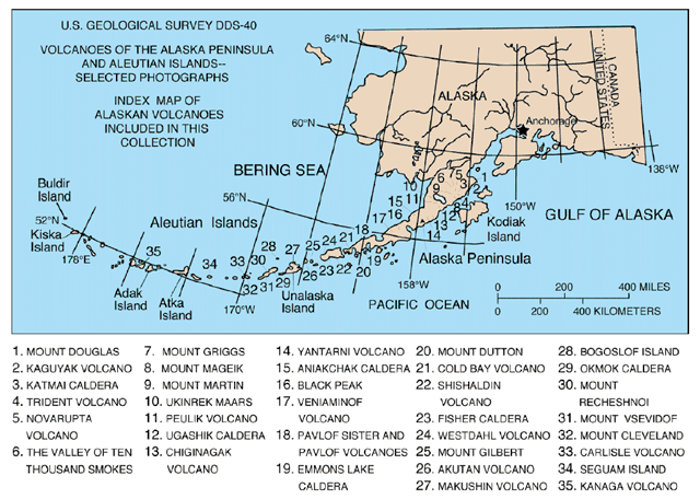


The Aleutian Islands (English pronunciation: /əˈl(j)uːʃən/; possibly from Chukchi aliat, "island") are a chain of 14 large volcanic islands and 57 smaller ones,[1] forming part of the Aleutian Arc in the Northern Pacific Ocean, occupying an area of 6,821 sq mi (17,666 km²) and extending about 1,200 mi (1,900 km) westward from the Alaska Peninsula toward the Kamchatka Peninsula, marking a line between the Bering Sea and the Pacific Ocean. Crossing longitude 180°, they are the westernmost part of the United States (and by one definition the easternmost; see Extreme points of the United States). Nearly all the archipelago is part of Alaska and usually considered as being in the "Alaskan Bush", but at the extreme western end the small, geologically related, and remote Commander Islands are in Russia. The islands, with their 57 volcanoes, are in the northern part of the Pacific Ring of Fire. The Alaska Marine Highway (a ferry service) passes through the islands. (wikipedia)

The "Ring of Fire" (map) is an arc stretching from New Zealand, along the eastern edge of Asia, north across the Aleutian Islands of Alaska, and south along the coast of North and South America. The Ring of Fire is composed over 75% of the world's active and dormant volcanoes.


The Aleutian Islands (English pronunciation: /əˈl(j)uːʃən/; possibly from Chukchi aliat, "island") are a chain of 14 large volcanic islands and 57 smaller ones,[1] forming part of the Aleutian Arc in the Northern Pacific Ocean, occupying an area of 6,821 sq mi (17,666 km²) and extending about 1,200 mi (1,900 km) westward from the Alaska Peninsula toward the Kamchatka Peninsula, marking a line between the Bering Sea and the Pacific Ocean. Crossing longitude 180°, they are the westernmost part of the United States (and by one definition the easternmost; see Extreme points of the United States). Nearly all the archipelago is part of Alaska and usually considered as being in the "Alaskan Bush", but at the extreme western end the small, geologically related, and remote Commander Islands are in Russia. The islands, with their 57 volcanoes, are in the northern part of the Pacific Ring of Fire. The Alaska Marine Highway (a ferry service) passes through the islands. (wikipedia)
The "Ring of Fire" (map) is an arc stretching from New Zealand, along the eastern edge of Asia, north across the Aleutian Islands of Alaska, and south along the coast of North and South America. The Ring of Fire is composed over 75% of the world's active and dormant volcanoes.
Tuesday, May 7, 2013
The Great Plains
| Feature Name | Type | Latitude | Longitude | GNIS ID | View Map | |||||
| Anaktuvuk Plateau | Plain | Unknown | Unknown | 1893309 | ||||||
| Chandalar Shelf | Plain | N68.0461° | W149.6086° | 1400142 | View Map | |||||
| Clinker Plateau | Plain | N56.6000° | W169.6667° | 1893958 | View Map | |||||
| Cushing Plateau | Plain | N58.9667° | W136.3333° | 1894038 | View Map | |||||
| Jagged Boulder Plateau | Plain | N63.7592° | W145.4044° | 1404065 | View Map | |||||
| Macomb Plateau | Plain | N63.5997° | W144.6867° | 1405854 | View Map |
The plains in Alaska are known as "tundra" and they are much like a normal desert; only much cooler in the winter. The tundra doesn't have very many trees, it mostly consists of ground cover plants, shrubs, rocks, and boulders.
Arctic Plains & Mountains – Alaska
Level IV Ducks Unlimited conservation priority area, part of the most important area for sea ducks in the world
The Arctic Coastal Plain contains one of the largest and most stable collections of wetlands in North America, bounded on the north and west by the Arctic Ocean and stretching eastward to the international boundary with the Yukon Territory. This poorly drained, treeless coastal plain rises gradually from sea level to the adjacent foothills and then abruptly into the glaciated Brooks Mountain range. The poor surface drainage results in wet tundra habitats that are dominated by mosses and herbaceous sedges and grasses on the coastal plain. Numerous thaw lakes and wetlands are also present. Many of the shallow thaw-lake wetlands are of greatest value to breeding waterfowl.

Subscribe to:
Posts (Atom)